CTD data collected during 12 long-term mooring cruises to Georges Bank as part of the U.S. GLOBEC project on R/V Columbus Iselin, R/V Endeavor, R/V Seward Johnson, R/V Albatross IV, and R/V Oceanus from 1994-1999 (GB project)
Project
Program
| Contributors | Affiliation | Role |
|---|---|---|
| Irish, Jim | Woods Hole Oceanographic Institution (WHOI) | Principal Investigator |
| Allison, Dicky | Woods Hole Oceanographic Institution (WHOI BCO-DMO) | BCO-DMO Data Manager |
GLOBEC Georges Bank Long-Term Moored Array Component
Standard CTD Sections
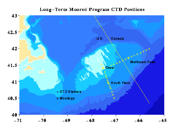
Long Term Section Stations
	LT01 41 31.0 N x 67 36.0 W
	LT02 41 24.5 N x 67 32.5 W
	LT03 41 17.0 N x 67 28.5 W
	LT04 41 12.5 N x 67 26.5 W
	LT05 41 09.5 N x 67 24.5 W
	LT06 41 06.0 N x 67 22.5 W
	LT07 41 02.0 N x 67 20.8 W
	LT08 40 58.0 N x 67 19.0 W
	LT09 40 54.5 N x 67 17.0 W
	LT10 40 50.5 N x 67 15.0 W
	LT11 40 47.0 N x 67 13.0 W
	LT12 40 41.5 N x 67 10.5 W
	LT13 40 35.7 N x 67 08.0 W
	LT14 40 30.0 N x 67 05.0 W

NE Peak Section Stations
	NE01 41 28.52 N x 67 12.17 W
	NE02 41 31.02 N x 67 05.77 W
	NE03 41 33.32 N x 66 57.77 W
	NE04 41 35.52 N x 66 50.87 W
	NE05 41 38.12 N x 66 43.07 W
	NE06 41 40.32 N x 66 35.97 W
	NE07 41 42.72 N x 66 28.77 W
	NE08 41 45.12 N x 66 21.67 W
	NE09 41 47.42 N x 66 14.37 W
	NE10 41 49.72 N x 66 06.67 W
	NE11 41 52.02 N x 65 58.87 W
	NE12 41 54.62 N x 65 51.77 W
	NE13 41 56.82 N x 65 44.57 W
	NE14 41 59.20 N x 65 37.50 W
Data submitted by:
James Irish
Woods Hole Oceanographic Institution
Woods Hole, MA 02543

phone:  508 289 2732
fax:    508 457 2195
e-mail: jirish@whoi.edu

Updated July 14, 2005, gfh
CTD for long term mooring cruises
| File |
|---|
ctd_ji.csv (Comma Separated Values (.csv), 11.23 MB) MD5:fcf785204f69a224447b1a6f2471e663 Primary data file for dataset ID 2403 |
| Parameter | Description | Units |
| cruiseid | cruise identification, i.e. en246 = Endeavor cruise 246 | |
| year_gmt | year, GMT | |
| instrument | CTD instrument model/brand | |
| station | preassigned station identifer | |
| cast | consecutive CTD cast number within cruise | |
| lat_begin | latitude at start of cast, negative = South | decimal degrees |
| lon_begin | longitude at start of cast, negative = West | decimal degrees |
| lat_end | latitude at end of cast, negative = South | decimal degrees |
| lon_end | longitude at end of cast, negative = West | decimal degrees |
| month_gmt | month of year, GMT time, (1-12) | |
| day_gmt | day of month, GMT time, (01-31) | |
| time_start_gmt | time at start of cast, GMT | HHmm |
| time_end_gmt | time at end of cast, GMT | HHmm |
| depth_w | depth of water | meters |
| press | depth of sample reported as pressure | decibars |
| temp | temperature | degrees C |
| sal | salinity. PSS | |
| sigma_0 | sigma-theta, potential density | kg/m3 |
| cond | conductivity | |
| O2C | oxygen sensor current | volts |
| O2T | oxygen sensor temperature | degrees C |
| trans_v | light transmission | volts |
| par | photosynthetically available radiation | volts |
| flvolt | fluorometer voltage measurements | volts |
| trans | Light transmission in percent. | percent |
| Dataset-specific Instrument Name | CTD Falmouth Scientific Instruments |
| Generic Instrument Name | CTD Falmouth Scientific Instruments |
| Dataset-specific Description | CTD measurements taken by the Falmouth Scientific Instruments sensor |
| Generic Instrument Description | CTD measurements taken by the Falmouth Scientific Instruments sensor. |
| Dataset-specific Instrument Name | MkIIICTD |
| Generic Instrument Name | CTD Neil Brown Mark III |
| Dataset-specific Description | formerly Neil Brown Mark III CTD, currently manufactured by General Oceanics |
| Generic Instrument Description | The Neil Brown Instrument Systems Mark III Conductivity, Temperature, Depth (CTD) instrument is an integral unit containing pressure, temperature and conductivity sensors with an optional dissolved oxygen sensor in a pressure-hardened casing. Developed in the 1970s, the Neil Brown CTD unit was able to digitize conductivity, temperature and pressure measurements at sufficient speeds to permit oceanographers to study 10 cm features at winch lowering speeds of 30 meters per minute. The most widely used variant in the 1980s and 1990s was the MK3B. The MK3C fitted with an improved pressure sensor to reduce hysteresis was developed to meet the requirements of the WOCE project. The instrument is no longer in production, but is supported (repair and calibration) by General Oceanics. |
| Dataset-specific Instrument Name | CTD Seabird 911 |
| Generic Instrument Name | CTD Sea-Bird 911 |
| Dataset-specific Description | CTD measurements taken by a SBE911 (SeaBird) CTD instrument package |
| Generic Instrument Description | The Sea-Bird SBE 911 is a type of CTD instrument package. The SBE 911 includes the SBE 9 Underwater Unit and the SBE 11 Deck Unit (for real-time readout using conductive wire) for deployment from a vessel. The combination of the SBE 9 and SBE 11 is called a SBE 911. The SBE 9 uses Sea-Bird's standard modular temperature and conductivity sensors (SBE 3 and SBE 4). The SBE 9 CTD can be configured with auxiliary sensors to measure other parameters including dissolved oxygen, pH, turbidity, fluorescence, light (PAR), light transmission, etc.). More information from Sea-Bird Electronics. |
| Dataset-specific Instrument Name | CTD Seabird 25 |
| Generic Instrument Name | Sea-Bird SBE 25 Sealogger CTD |
| Dataset-specific Description | CTD measurements taken by a SBE25 (Seabird) CTD instrument package. |
| Generic Instrument Description | The Sea-Bird SBE 25 SEALOGGER CTD is battery powered and is typically used to record data in memory, eliminating the need for a large vessel, electrical sea cable, and on-board computer. All SBE 25s can also operate in real-time, transmitting data via an opto-isolated RS-232 serial port. Temperature and conductivity are measured by the SBE 3F Temperature sensor and SBE 4 Conductivity sensor (same as those used on the premium SBE 9plus CTD). The SBE 25 also includes the SBE 5P (plastic) or 5T (titanium) Submersible Pump and TC Duct. The pump-controlled, TC-ducted flow configuration significantly reduces salinity spiking caused by ship heave, and in calm waters allows slower descent rates for improved resolution of water column features. Pressure is measured by the modular SBE 29 Temperature Compensated Strain-Gauge Pressure sensor (available in eight depth ranges to suit the operating depth requirement). The SBE 25's modular design makes it easy to configure in the field for a wide range of auxiliary sensors, including optional dissolved oxygen (SBE 43), pH (SBE 18 or SBE 27), fluorescence, transmissivity, PAR, and optical backscatter sensors. More information from Sea-Bird Electronics: http:www.seabird.com. |
CI9405
| Website | |
| Platform | R/V Columbus Iselin |
| Report | |
| Start Date | 1994-05-07 |
| End Date | 1994-05-10 |
| Description | long term mooring Methods & Sampling CTD for long term mooring cruises |
EN246
| Website | |
| Platform | R/V Endeavor |
| Report | |
| Start Date | 1994-06-28 |
| End Date | 1994-07-01 |
| Description | long term mooring Methods & Sampling CTD for long term mooring cruises |
EN256
| Website | |
| Platform | R/V Endeavor |
| Report | |
| Start Date | 1994-10-26 |
| End Date | 1994-10-31 |
| Description | long term mooring deployment Methods & Sampling CTD for long term mooring cruises |
SJ9504
| Website | |
| Platform | R/V Seward Johnson |
| Report | |
| Start Date | 1995-03-27 |
| End Date | 1995-04-04 |
| Description | long term mooring turn-around Methods & Sampling CTD for long term mooring cruises |
EN274
| Website | |
| Platform | R/V Endeavor |
| Report | |
| Start Date | 1995-09-29 |
| End Date | 1995-10-05 |
| Description | long term mooring recovery Methods & Sampling CTD for long term mooring cruises |
AL9513
| Website | |
| Platform | R/V Albatross IV |
| Report | |
| Start Date | 1995-10-30 |
| End Date | 1995-11-08 |
| Description | long term mooring deployment Methods & Sampling CTD for long term mooring cruises |
OC276
| Website | |
| Platform | R/V Oceanus |
| Start Date | 1996-03-30 |
| End Date | 1996-04-13 |
| Description | long term mooring Methods & Sampling CTD for long term mooring cruises |
EN288
| Website | |
| Platform | R/V Endeavor |
| Start Date | 1996-09-06 |
| End Date | 1996-09-13 |
| Description | long term mooring Methods & Sampling CTD for long term mooring cruises |
OC291
| Website | |
| Platform | R/V Oceanus |
| Report | |
| Start Date | 1996-10-24 |
| End Date | 1996-10-31 |
| Description | mooring cruise Methods & Sampling CTD for long term mooring cruises |
OC331
| Website | |
| Platform | R/V Oceanus |
| Report | |
| Start Date | 1998-10-04 |
| End Date | 1998-10-13 |
| Description | long term mooring turn-around Methods & Sampling CTD for long term mooring cruises |
OC344
| Website | |
| Platform | R/V Oceanus |
| Report | |
| Start Date | 1999-07-06 |
| End Date | 1999-07-11 |
| Description | long term mooring Methods & Sampling CTD for long term mooring cruises |
OC346
| Website | |
| Platform | R/V Oceanus |
| Report | |
| Start Date | 1999-08-11 |
| End Date | 1999-08-20 |
| Description | long term mooring Methods & Sampling CTD for long term mooring cruises |
U.S. GLOBEC Georges Bank (GB)
The U.S. GLOBEC Georges Bank Program is a large multi- disciplinary multi-year oceanographic effort. The proximate goal is to understand the population dynamics of key species on the Bank - Cod, Haddock, and two species of zooplankton (Calanus finmarchicus and Pseudocalanus) - in terms of their coupling to the physical environment and in terms of their predators and prey. The ultimate goal is to be able to predict changes in the distribution and abundance of these species as a result of changes in their physical and biotic environment as well as to anticipate how their populations might respond to climate change.
The effort is substantial, requiring broad-scale surveys of the entire Bank, and process studies which focus both on the links between the target species and their physical environment, and the determination of fundamental aspects of these species' life history (birth rates, growth rates, death rates, etc).
Equally important are the modelling efforts that are ongoing which seek to provide realistic predictions of the flow field and which utilize the life history information to produce an integrated view of the dynamics of the populations.
The U.S. GLOBEC Georges Bank Executive Committee (EXCO) provides program leadership and effective communication with the funding agencies.
U.S. GLOBal ocean ECosystems dynamics (U.S. GLOBEC)
U.S. GLOBEC (GLOBal ocean ECosystems dynamics) is a research program organized by oceanographers and fisheries scientists to address the question of how global climate change may affect the abundance and production of animals in the sea.
The U.S. GLOBEC Program currently had major research efforts underway in the Georges Bank / Northwest Atlantic Region, and the Northeast Pacific (with components in the California Current and in the Coastal Gulf of Alaska). U.S. GLOBEC was a major contributor to International GLOBEC efforts in the Southern Ocean and Western Antarctic Peninsula (WAP).
| Funding Source | Award |
|---|---|
| National Science Foundation (NSF) | |
| National Oceanic and Atmospheric Administration (NOAA) |
[ table of contents | back to top ]